As custodians of the soil survey of England and Wales, our research group is focussed on interpretation and visualisation of soil data and the policy and practitioner support afforded by these assets. We develop the data science to model and map soil properties, processes and functions using state of the art geospatial technologies and models that integrate different forms of data. This also involves translating and improving soil spatial data to advance our knowledge of soil resources at field, national and global scales.
The assets, the accompanying soil systems science and models developed for decision making are invaluable to support policy development in soil quality and land management. Our research determines new mechanisms and responses of soil systems to environmental pressures and informs wider environmental system decision making, policy and application. Our work spans not only across the university but also across Government departments from Defra to MoD (in close collaboration with Cranfield Defence and Security).The group teaches across the Environment and Agrifood MSc teaching programmes, contributes to the MK:U teaching delivery on data sciences and supports numerous PhD researchers in UKRI doctoral training partnerships.
Our core research areas focus on:
- Integrating soil and spatial environment data with new sensing technologies,
- Digital soil mapping,
- Land information systems and soil decision support tools,
- Ecological modelling of soil biological community and population response to environmental change,
- Spatial modelling of soil carbon at national to field scales.
Clients
NERC, UKCRIC, AgSpace, Defra, Welsh Government, British Sugar, UK Innovate, Forestry Commission, G's Growers, European Environmental Protection Agency, European Space Agency, Joint Research Centre (EU), FP7 (EU), H2020 (EU).
Facilities
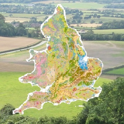
In our role as the National Reference Centre for soil we manage soil datasets for England and Wales on behalf of Defra (LandIS) and are custodians of the National Soil Archive of reference samples and materials from the activities of the Soil Survey of England and Wales. We host a global data rescue facility for soil information that contains data from 348 territories worldwide (WOSSAC).
Digital Soil Mapping
Good quality spatial information about the soil at the appropriate scale is a necessary requirement for understanding soil functioning, its quality and value. DSM provides this information.
Soils are by nature heterogeneous and consequently obtaining exhaustive spatial information on soil properties is resource and time consuming. There is also an enormous amount of legacy and existing soil information that is semi-quantitative or qualitative rather than strictly quantitative. Digital Soil Mapping is the nexus where existing and new environmental data are combined with quantitative landscape models to supply much needed spatial information on soil properties. Our interest is in the development and use of mathematical and statistical models to generate predictions on soil properties. These mathematical models are then used to predict soil properties at unsampled locations with uncertainty at local, regional, national and global scales. Integrating this information into soil process or functional models results in a digital assessment of land capability.
- Xiong, X., Grunwald, S., Corstanje R., Yu, C., Bliznyuk, N., Scale-dependent variability of soil organic carbon coupled to land use and land cover. Soil Tillage Research, 160: 101-109 (2016).
- Albanito, F., Beringer, T., Corstanje, R., Poulter, B., Stephenson, A. Zawadzka, J. Smith, P. Carbon Implications of Converting Cropland to Bioenergy Crops or Forest for Climate Mitigation: A Global Assessment. Global Change Biology Bioenergy, 8: 81–95 (2016).
- Simo, I., Schulte, R.P.O., Corstanje, R., Hannam, J., Creamer, R.E. Validating digital soil maps using soil taxonomic distance: A case study of Ireland. Geoderma Regional, 5, 188–197 (2015)
- Taalab, K., Corstanje, R., Whelan, M.K., Creamer, R., On the Application of Bayesian Belief Networks in Digital Soil Mapping. Geoderma 259-260: 134-148 (2015)
- Taalab, K., Corstanje, R., Whelan, M.K., Creamer, R., On the use of expert knowledge in Soil Mapping. European Journal of Soil Science, 66: 930–941 (2015)
- Zawadzka J., Mayr, T., Bellamy, P., Corstanje, R., Comparing physiographic maps with different categorisations, Geomorphology, 231: 94-100 (2015).
- Veronesi, F., Corstanje, R., Mayr, T. Landscape scale estimation of soil carbon stock in three-dimensions. Science for the Total Environment. 487: 578-586 (2014).
- Taalab, K., Corstanje, R., Creamer, R., Whelan, M. Predicting soil bulkdensity at the landscape scale and its consequences to uncertainty in C stock estimations. Biogeosciences, 10:4691-4704 (2013).
- Cavazzi, S., Corstanje R., Mayr T., Hannam J., Fealy R.. Are fine resolution digital elevation models always the best choice in digital soil mapping? Geoderma, 195–196: 111-121 (2013).