Experts from Cranfield University are helping to protect one of the UK’s rarest species of wildlife, by providing data that allows environmentalists to identify habitats in which it can thrive.
Due to a rapid decline in numbers during the last century, great crested newts are protected in law, meaning that developers wanting to build on land where they have made a home must wait until they have been relocated before beginning work. Previously, the relocation process was ad-hoc, and subject to seasonal restrictions, delays and uncertainty. But data from Cranfield’s Land Information System (LandIS) is feeding into a new model that promises to result in better outcomes for the species, as well as make developers’ lives easier.
Under Natural England’s district level licensing (DLL), developers make a conservation payment based on the predicted impact of their development. The money is used to fund the strategic creation or restoration of ponds in areas which are known to represent the best places for newts to thrive. The new habitats created will then be maintained and monitored for 25 years, all funded by the initial payment.
Dr Jacqueline Hannam, Senior Research Fellow in Pedology within Cranfield’s Centre for Environmental and Agricultural Informatics, said: “District level licensing promises to result in fewer delays and uncertainties within the planning process but – more importantly – it focuses conservation effort where it will be of maximum benefit to the great crested newt species. LandIS data on the soil properties of different areas will feed into a wider geospatial analysis and be combined with ecological knowledge gathered from observational surveys, enabling Natural England to create a map of Strategic Opportunity Areas that will guide wildlife trusts regarding placing or restoring compensation ponds.”
Dr Ben Payne, Senior Adviser in Natural England's Modelling and Analysis Team, said: “Understanding the soil properties, using Cranfield soils (drainage) data for example, as well as terrestrial habitat and pondscape characteristics, all contribute to improving the performance of the models and their ability to predict suitable habitat for great crested newts.”
Karen Kramer Wilson, Senior Adviser for Species Data Use and Mobilisation at Natural England, added: “This is a great example of effective integration of multiple sources of valuable data to achieve a dynamic and relevant approach to inform key conservation efforts on a local and landscape level.”
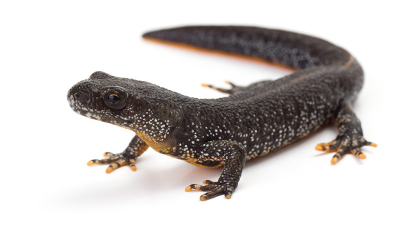
The great crested newt is the largest of the UK’s three native species of newt, growing up to 17cm long. Dark brown or black, with distinctive ‘warty’ skin and an orange underside with irregular black blotches, males of the species display an impressive jagged crest along their back in Spring and a white ‘flash’ in their tail.
Due to a rapid decline in numbers during the last century, the great crested newt is strictly protected in British and European law. It is illegal to kill, injure, capture, keep, sell or trade them, and to disturb, damage or destroy their habitat.
District Level Licensing is currently available across 130 local authorities in England, and Natural England has plans to expand this beyond 150 local authorities in the coming months. Going forwards, its ambition is to consider species conservation strategies for other protected species.
LandIS, the Land Information System, is a substantial environmental information system operated by Cranfield University, designed to contain soil and soil-related information for England and Wales including spatial mapping of soils at a variety of scales, as well as corresponding soil property and agro-climatological data. LandIS is the largest system of its kind in Europe and is recognised by UK Government as the definitive source of national soils information.